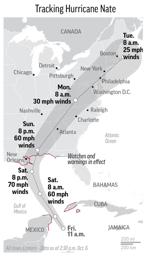
Hurricane Nate made landfall late Saturday and now the storm is making its way up the Eastern Seaboard as those in the Gulf Coast are dealing with its aftermath.
UPDATE 11 a.m. ET: Nate remnants now soaking the Mid-Atlantic.
UPDATE 9 a.m. ET Monday: Hurricane Nate’s price tage: $500 million.
UPDATE 11 p.m. ET: U.S. 90, a major east-west highway that runs parallel to the Mississippi Gulf Coast, is opening back up to traffic after Nate’s landfall made the road impassable.
UPDATE 10:45 p.m. ET: At least 18 tornados from Nate reported in the Carolinas.
UPDATE 10:15 p.m. ET: Power has been restored to Mississippi Power customer that had outages from Nate’s arrival. Around 33,000 customers of Singing River Electric remain in the dark.
UPDATE 10 p.m. ET: Watch drone footage of piers along Mobile Bay near Fairhope, AL that sustained damage from Hurricane Nate
UPDATE 9:30 p.m. ET: Remnants of Nate are moving through Pennsylvania and into New York State.
UPDATE 8:30 p.m. ET: Power outages still plague Alabama’s major population centers Birmingham and Mobile
UPDATE 7 p.m. ET: Watch NOAA satellite’s capture of the fast moving storm —
UPDATE 6 p.m. ET: Tropical depression Nate leaving a footprint in the Upstate South Carolina, Western North Carolina. Power outages reported, tornado warnings underway.
UPDATE 3:45 p.m. ET: The remnants of Nate are leaving a path of damage as it moves further inland.
UPDATE 2 p.m. ET: More images of storm damage from Nate along the southeastern Gulf Coast
UPDATE 1:40 p.m. ET: 146k power impacted by Nate per Alabama Power, 32k impacted in Mississippi per the Sun-Herald (MS).
UPDATE 1:30 p.m. ET: NOAA’s Weather Prediction Center issues advisory on Tropical Depression Nate for parts of Georgia, South Carolina and North Carolina.
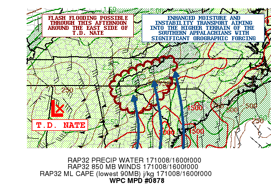
MESOSCALE PRECIPITATION DISCUSSION 0878
NWS WEATHER PREDICTION CENTER COLLEGE PARK MD
131 PM EDT SUN OCT 08 2017

AREAS AFFECTED...NORTHEAST GA...NORTHWEST SC...WESTERN NC...FAR
EASTERN TN

CONCERNING...HEAVY RAINFALL...FLASH FLOODING POSSIBLE

VALID 081730Z - 082330Z

SUMMARY...VERY HEAVY RAINS ARE EXPECTED OVER THE NEXT SEVERAL
HOURS OVER THE HIGHER TERRAIN OF THE SOUTHERN APPALACHIANS. SOME
FLASH FLOODING WILL BE POSSIBLE.

DISCUSSION...T.D. NATE CONTINUES TO LIFT QUICKLY NORTH-NORTHEAST
UP ACROSS WESTERN AL AND SHOULD MOVE UP ACROSS SOUTHERN TN BY
AROUND 21Z. THERE CONTINUES TO BE A VERY STRONG INFLUX OF DEEP
TROPICAL MOISTURE ALONG WITH ENHANCED SURFACE CONVERGENCE AROUND
THE EASTERN SEMICIRCLE OF NATE...WITH MULTIPLE BANDS OF WELL
ORGANIZED CONVECTION. THE STRONGEST CONVECTIVE BAND EXTENDS FROM
FAR SOUTHEAST TN SOUTHWARD DOWN ACROSS MUCH OF CENTRAL GA WITH A
LINEAR AXIS OF VERY INTENSE RAINFALL RATES. THE INDIVIDUAL CELL
MOTION IS RAPIDLY OFF TO THE NORTH...BUT THERE IS A BRIEF PERIOD
CELL-TRAINING OCCURRING AS THE OVERALL BAND SHIFTS GRADUALLY TO
THE NORTHEAST.

THE LATEST RAP GUIDANCE FAVORS A SOUTHEAST LOW LEVEL JET OF 50 TO
60 KTS AIMING INTO THE HIGHER TERRAIN OF THE SOUTHERN APPALACHIANS
THIS AFTERNOON WITH AN EMPHASIS ON NORTHEAST GA...NORTHWEST SC AND
WESTERN NC WHILE THE CENTER OF NATE BEGINS TRACKING UP THROUGH THE
TN VALLEY. THE CIRA-LPW DATA SHOWS AND ALREADY VERY MOIST
ENVIRONMENT WITH PWATS JUST OVER 2 INCHES...BUT THESE VALUES WILL
LIKELY INCREASE FURTHER WITH A NOSE OF 2.25 TO 2.5 INCH PWATS
EXPECTED TO NOSE UP ACROSS THE SOUTHEAST PIEDMONT AND INTO THE
FAVORED SOUTHEAST FACING TERRAIN THROUGH MID TO LATE AFTERNOON.
THERE IS MUCH GREATER INSTABILITY ALSO NOTED ACROSS THE SOUTHEAST
COASTAL PLAIN WITH THE LATEST RAP ANALYSIS SHOWING A NOSE OF
MLCAPE VALUES EXCEEDING 1500 J/KG LIFTING UP ACROSS EASTERN GA
AHEAD OF THE AFOREMENTIONED CONVECTIVE BANDING.

THE MOISTURE AND INSTABILITY TRANSPORT WILL BE QUITE STRONG AND
WILL FAVOR SUSTAINABLE CONVECTIVE BANDS WITH RAINFALL RATES THAT
MAY APPROACH 3 INCHES/HR. THIS WILL BE AIDED BY OROGRAPHIC ASCENT.
DESPITE QUITE HIGH FFG VALUES...THE INTENSE RAINFALL RATES OVER
THE HIGHER TERRAIN WILL ENCOURAGE SOME RAPID RUNOFF AND MAY RESULT
IN SOME ENHANCED SHORT-TERM FLASH FLOODING CONCERNS. EXPECT
RAINFALL TOTALS THROUGH 00Z OF AS MUCH AS 4 TO 6+ INCHES. WILL
CONTINUE TO MONITOR.
UPDATE 12:30 p.m. ET: Trump approves Alabama governor’s disaster declaration.
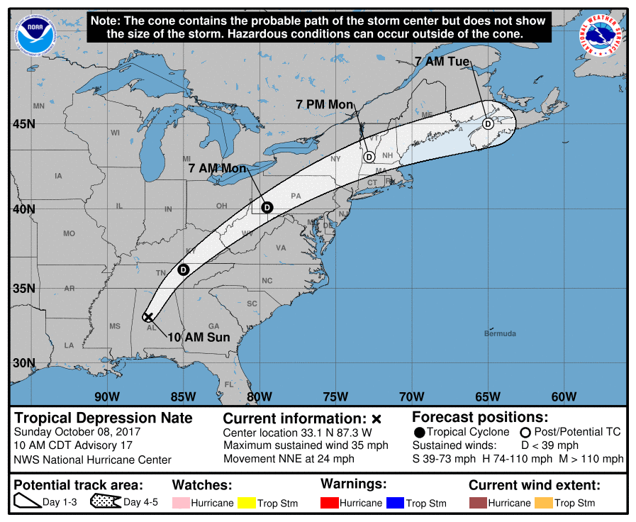
UPDATE 11:15 a.m. ET: Nate downgraded to a tropical depression.
The National Hurricane Center’s latest advisory has the storm making its first landfall located at 33.1°N 87.3°W, moving north at 24 mph, 40 miles southwest of Birmingham, AL.
UPDATE: 10:15 a.m. ET: Tropical Storm Nate ‘rapidly weakening’ — Still poses threat inland
The National Hurricane Center’s latest advisory has the storm making its first landfall located at 32.0°N 88.0°W, moving north at 23 mph, 95 miles southwest of Montgomery, AL.
UPDATE 10 a.m. ET: 71k without power in Alabama.
UPDATE 9:45 a.m. ET: As daylight arrives, the Gulf Coast surveys damages.
UPDATE 7:15 a.m. ET: 59k without power in Alabama
UPDATE 7 a.m. ET: Downtown Mobile, AL under water.
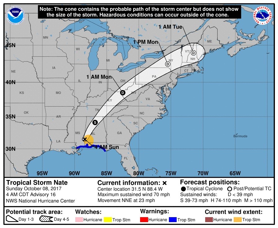
UPDATE 6 a.m. ET: Nate downgraded to a tropical storm.
The National Hurricane Center’s latest advisory has the storm making its first landfall located at 31.5°N 88.4°W, moving north at 20 mph, 135 miles south of Montgomery, AL.
UPDATE 2 a.m. ET: Nate remains a hurricane.
The National Hurricane Center’s latest advisory has the storm making its first landfall located at 30.5°N 88.9°W, moving north at 20 mph, 5 miles north of Biloxi.
UPDATE 1:30 a.m. ET: National Hurricane Center declares Nate has made its second landfall near Biloxi, MS.
The latest data has the storm located at 30.4°N 89.0°W, inland moving north at 20 mph.
UPDATE 1 a.m. ET: More storm surge images from Biloxi, MS
UPDATE 12:30 a.m. ET: Instances of storm surge reported along the coastlines of Mississippi and Alabama
UPDATE 12:15 a.m. ET Sunday: New Orleans spared from the brunt of Hurricane Nate
UPDATE 11:45 p.m. ET: Power outages starting to increase along the Gulf Coast
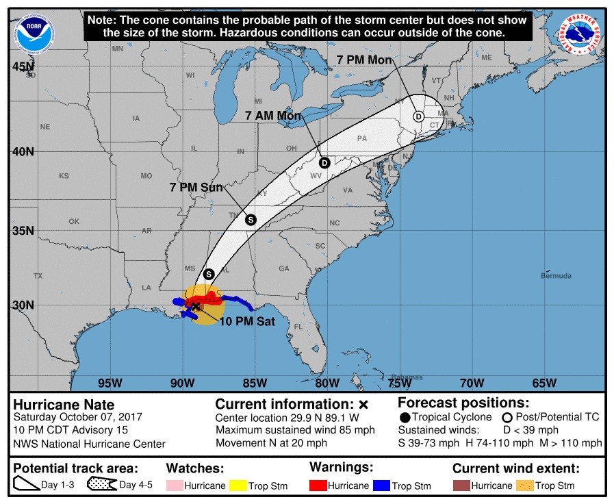
UPDATE 11 p.m. ET: The National Hurricane Center’s latest advisory has the storm located at 29.9°N 89.1°W, moving north at 20 mph, 35 miles south of the mouth of Biloxi, MS.
UPDATE 10:30 p.m. ET: Hurricane Nate on the verge of making its second landfall
UPDATE 9:30 p.m. ET: Nate is nearing the Mississippi coast for another landfall
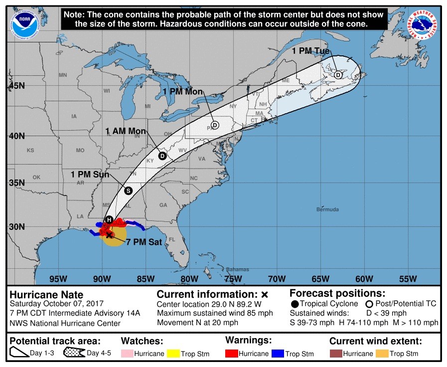
UPDATE 8 p.m. ET: The National Hurricane Center’s latest advisory has the storm making its first landfall located at 29.0°N 89.2°W, moving north at 20 mph, 10 miles south of the mouth of the Mississippi River.
UPDATE 7:55 p.m. ET: Hurricane Nate makes first landfall near the mouth of the Mississippi River.
UPDATE 7:50 p.m. ET: Multiple tornado warnings issued along the Alabama coastline.
UPDATE 7:45 p.m. ET: The Mobile Bay Causeway in Alabama now covered in water as a result of storm surge
UPDATE 7:30 p.m. ET: Surf picks up around the Gulf Coast as Nate nears landfall.
UPDATE 6 p.m. ET: Hurricane Nate the “fastest” forward-motion moving recorded hurricane in the Gulf of Mexico according to the National Weather Service.
UPDATE 5 p.m. ET: Portions of the hurricane watch in Louisiana have been canceled.
UPDATE 4:45 p.m. ET: The National Hurricane Center’s latest advisory has the storm located at 28.4°N 89.1°W, moving north at 23 mph, 50 miles south of the mouth of the Mississippi River.
UPDATE 3:45 p.m. ET: Hurricane Nate’s arrival at the Mississippi-Alabama state line anticipated to pack 100 mph winds, per AL.com.
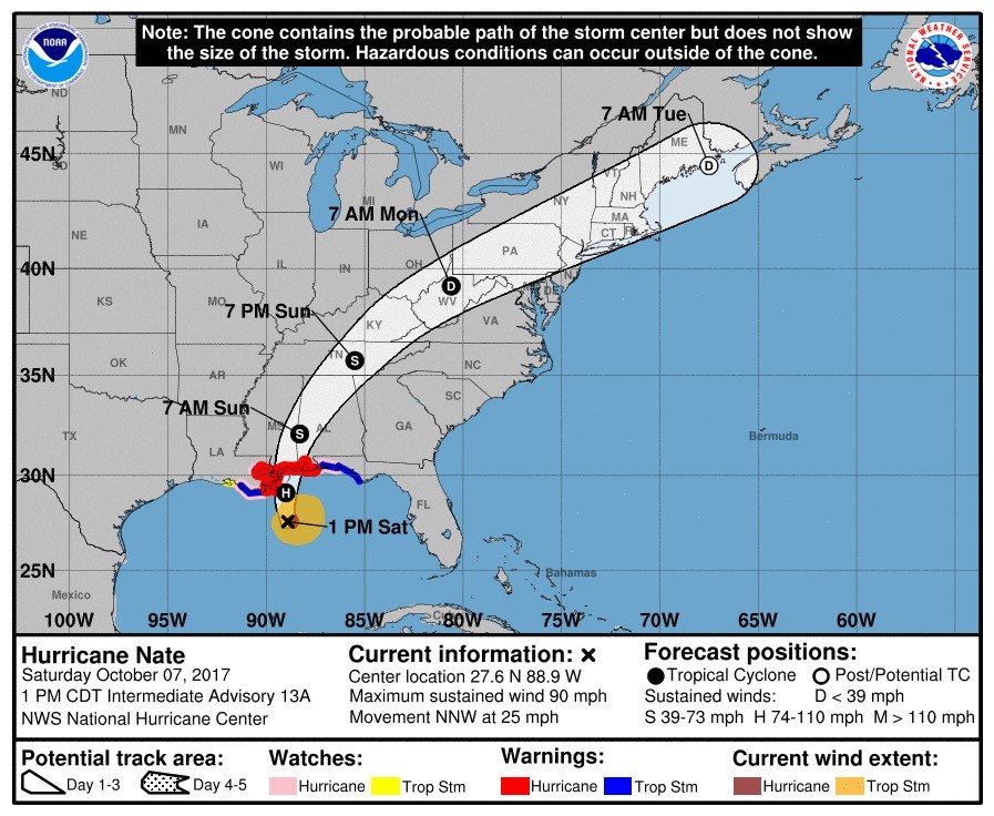
UPDATE 3:15 p.m. ET: The National Hurricane Center’s latest advisory has the storm located at 27.6°N 88.9°W, moving north at 26 mph, 105 miles south of the mouth of the Mississippi River.
UPDATE 3 p.m. ET: Waterspout spotted off the coast of Alabama, spawned from Nate. Area also under a tornado warning
UPDATE 2 p.m. ET: Nearly the entire state of Alabama is under a watch or warning due to Hurricane Nate
UPDATE 1:30 p.m. ET: The National Weather Service in New Orleans emphasizes why those under mandatory evacuation orders should adhere to them.
UPDATE 1 p.m. ET: Tropical storm force winds are forecasted from Louisiana to Maine.
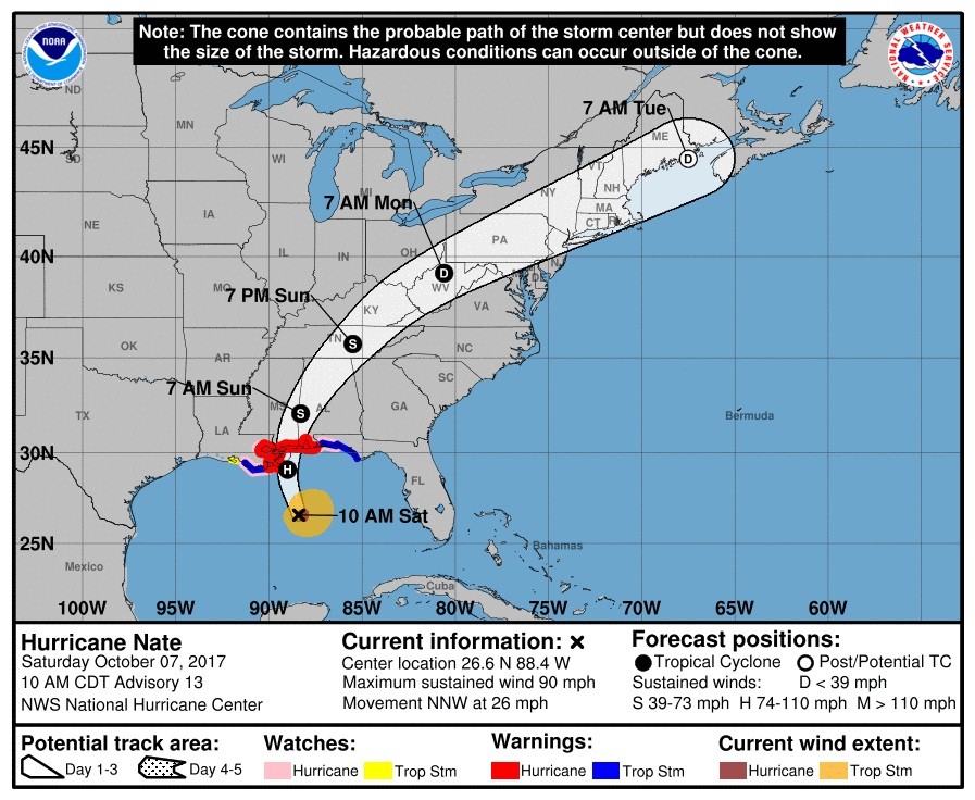
UPDATE 12 p.m. ET: The National Hurricane Center’s latest advisory has the storm located at 26.6°N 88.4°W, moving north at 26 mph, 180 miles south of the mouth of the Mississippi River.
UPDATE 11:30 a.m. ET: Outer rain bands from Hurricane Nate are arriving in southeastern Louisiana.
UPDATE 11 a.m. ET: Nate now expected to make landfall as a Category 2, per National Hurricane Center.
UPDATE 10:30 a.m. ET: Storm surge warnings remain in effect from Louisiana to Florida.
UPDATE 10 a.m. ET: The National Hurricane Center’s latest advisory has the storm located at 25.7°N 88.0°W, moving north at 22 mph, 245 miles south of the mouth of the Mississippi River.
UPDATE 9:30 a.m. ET: Hurricane Nate expected to be packing winds of 90 mph when it makes landfall later today.
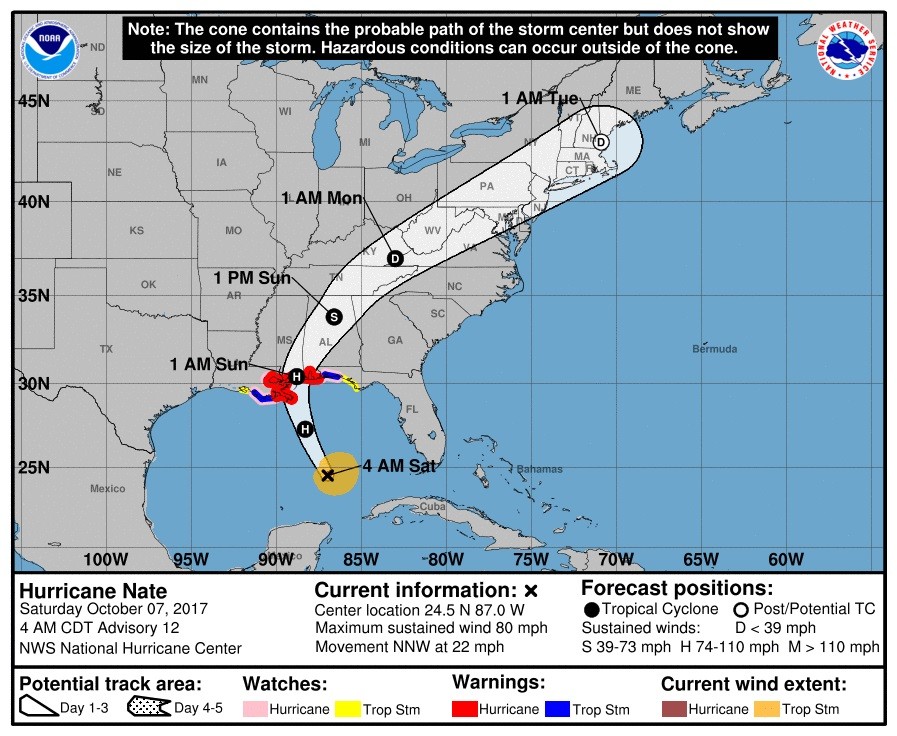
UPDATE: 6 a.m. ET: The National Hurricane Center’s latest advisory has the storm located at 24.5°N 87.0°W, moving north at 22 mph, 345 miles south of the mouth of the Mississippi River.
UPDATE 3 a.m. ET: Forecasts show after Nate makes landfall, its remnants could make their way up the Eastern Seaboard and directly impact Washington, DC, Philadelphia, New York City and Boston.
UPDATE 2:30 a.m. ET: Meteorologists anticipate further strengthening by Nate as the Gulf Coast braces for Saturday evening landfall.
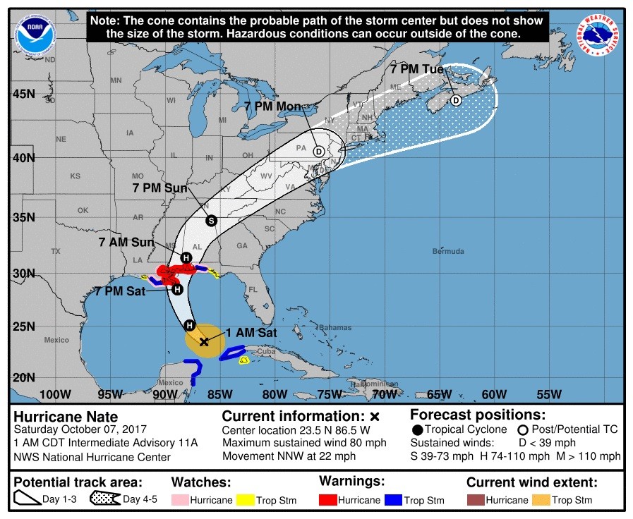
UPDATE: 1:45 a.m. ET: The National Hurricane Center’s latest advisory has the storm located at 23.5°N 86.5°W, moving north at 22 mph, 420 miles south of the mouth of the Mississippi River.
UPDATE 12:45 a.m. ET Saturday: Winds within Hurricane Nate now up to 75 mph.
UPDATE: 11:30 p.m. ET: Nate is now classified as a Category 1 hurricane per The Weather Channel.
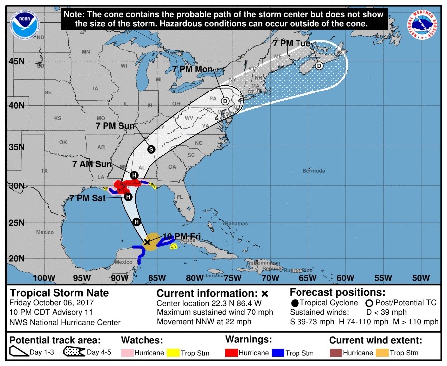
UPDATE 11:00 p.m. ET: The National Hurricane Center’s latest advisory has the storm located at 22.3°N 86.4°W, moving north at 22 mph, 500 miles south of the mouth of the Mississippi River.
The National Hurricane Center has the watches and warnings listed as below:
SUMMARY OF WATCHES AND WARNINGS IN EFFECT:
A Hurricane Warning is in effect for...
* Grand Isle Louisiana to the Alabama/Florida border
* Metropolitan New Orleans and Lake Pontchartrain

A Storm Surge Warning is in effect for...
* Morgan City Louisiana to the Okaloosa/Walton County Line Florida
* Northern and western shores of Lake Pontchartrain

A Tropical Storm Warning is in effect for...
* Punta Herrero to Rio Lagartos Mexico
* Pinar del Rio Cuba
* Lake Maurepas
* West of Grand Isle to Morgan City Louisiana
* East of the Alabama/Florida border to the Okaloosa/Walton County
Line.

A Hurricane Watch is in effect for...
* Lake Maurepas
* East of the Alabama/Florida border to the Okaloosa/Walton County
Line
* West of Grand Isle to Morgan City Louisiana

A Storm Surge Watch is in effect for...
* East of the the Okaloosa/Walton County Line to Indian Pass Florida

A Tropical Storm Watch is in effect for...
* East of the Okaloosa/Walton County Line to Indian Pass Florida
* West of Morgan City to Intracoastal City Louisiana
* Isle of Youth Cuba
Follow Jeff Poor on Twitter @jeff_poor




COMMENTS
Please let us know if you're having issues with commenting.